Tech and Innovation
Indonesia has one of the largest tropical forest areas in the world, but it also faces major pressures from deforestation, forest fires, and land conversion. The vast size and difficult access to the field make manual forest monitoring almost impossible to carry out quickly and comprehensively. This is why satellite-based technology has become such an important solution. One of the most widely used indicators is NDVI.
NDVI (Normalized Difference Vegetation Index) is an index used to measure the level of vegetation greenness based on the reflection of light from the Earth's surface. The principle is simple: healthy plants absorb red light for photosynthesis and reflect near-infrared light. Conversely, unhealthy plants or bare land reflect more red light and less infrared.
NDVI = (NIR - RED) / (NIR + RED)
NDVI values range from -1 to +1. Values close to +1 indicate healthy vegetation, while values close to 0 or negative indicate sparse vegetation, bare soil, or even water surfaces.
NDVI provides data that is fast, objective, and can be monitored regularly. This is very important for forests because:
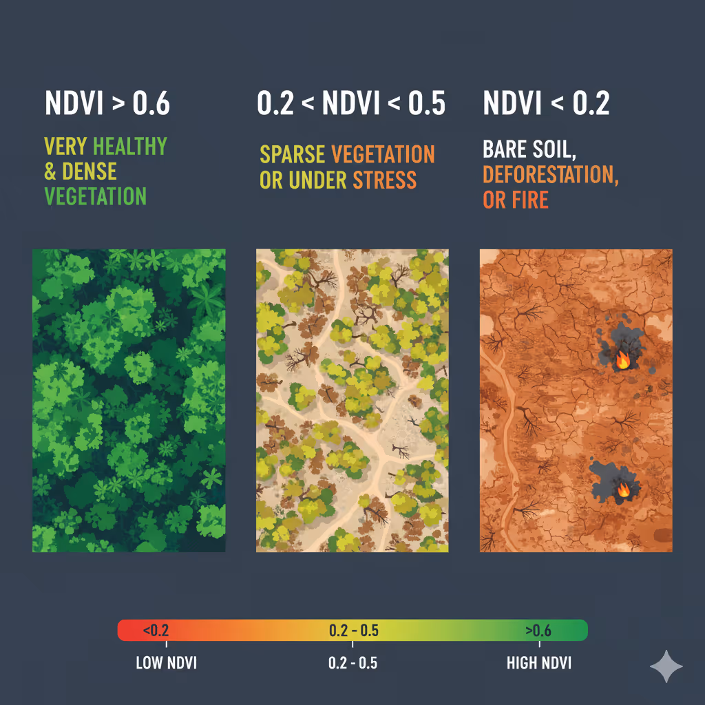
Imagine a dense forest in Kalimantan. With a regular satellite, we would only see a green area. But with NDVI, differences in vegetation levels can be measured quantitatively. For example:
With NDVI maps, governments and conservation agencies can know which areas need attention faster without waiting for manual reports.
In 2019, large forest fires struck Kalimantan and Sumatra. Satellite images with NDVI showed a drastic decline in vegetation in affected areas within just a few days. This data helped the government and international agencies map critical areas for emergency response and recovery.
On the other hand, some reforestation projects in West Java use NDVI to evaluate the success of tree planting. From NDVI data, it was seen that certain areas showed significant increases in vegetation cover within two years, while others stagnated and required additional intervention.
NDVI is simple and popular, but it also has limitations. For example, it is difficult to distinguish very dense healthy vegetation from moderate vegetation at certain scales. Therefore, NDVI is often combined with other technologies such as:
This combination makes forest condition analysis more accurate and comprehensive.
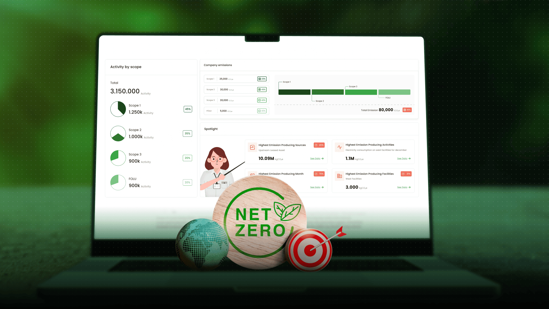
Indonesia is committed to FOLU Net Sink 2030, which aims to make the forestry and land sector a net carbon sink by 2030. To achieve this target, transparent and data-based monitoring is urgently needed. NDVI is one of the key tools supporting emission reporting, carbon absorption, and conservation policy effectiveness.
Through the CarbonAtlas platform, Jejakin integrates NDVI data with IoT and AI. The goal is to provide forest monitoring information that is more transparent, faster, and easier to use by governments, businesses, and communities. From monitoring deforestation, assessing the success of reforestation, to supporting carbon emission reports, NDVI is an important part of Jejakin’s data-driven solutions.
NDVI is not just a number from a satellite. It is a window to see forest health, detect threats more quickly, and support sustainable decisions. Amid the challenges of monitoring Indonesia’s vast and complex forests, this technology is one of the most important tools for protecting the lungs of the Earth.
If you want to know how NDVI and other technologies can help your conservation or sustainability project, contact the Jejakin team and discover data-driven solutions through CarbonAtlas.


Jejakin’s green programs combine high-tech monitoring, biodiversity restoration, and community-led initiatives to deliver powerful, sustainable change across ecosystems.