Tech and Innovation
According to the IPCC Sixth Assessment Report, a carbon monitoring system that is transparent and verifiable is a key foundation in global climate change mitigation efforts.
When a company, government, or organization runs a decarbonization program, one important question always arises: can the reported emissions data truly be trusted?
This is where the concept of MRV (Monitoring, Reporting, and Verification) plays an important role. MRV is not merely a process of recording carbon emissions. The system is designed to ensure that every piece of reported data can be measured accurately, traced back to its source, and verified by an independent party.
Without a strong MRV system, emission reduction claims can lose their credibility. Investors, regulators, and the public need transparent evidence, not just reported figures.
For this reason, advances in digital technology have begun to drive the emergence of a new approach: digital Monitoring, Reporting, and Verification (dMRV), which integrates field data with technology-based spatial systems.
According to the GHG Protocol, a credible emissions report must meet the principles of transparency, accuracy, consistency, and verifiability.
In practice, this means that every piece of data entering an MRV system must have three main characteristics.
First, the data must be measurable. Activities that generate emissions need to be calculated with a clear method, whether through direct measurement, activity-based calculation, or an internationally recognized scientific model.
Second, the data must be traceable. Every emission figure needs to have a clear data-source trail, including location, time of data collection, and the collection method.
Third, the data must be verifiable. Independent auditors must be able to review the data collection process to ensure that the reported figures truly reflect conditions in the field.
When these three principles are met, a carbon report becomes more than an administrative document. It turns into evidence that can be trusted by regulators, investors, and the global carbon market.
Many organizations still manage MRV data using spreadsheets or manual reports. This approach often creates major challenges when the verification process is carried out.
Without an integrated spatial system, the relationship between field data and geographic location is often unclear. Activity data may be recorded, but the evidence of where activities took place becomes difficult to trace.
As a result, several common problems frequently arise:
In the context of the carbon market and ESG reporting, this situation can reduce the credibility of a report and slow down the project validation process.
For this reason, the integration of spatial data has become an important element in developing modern MRV systems.
Advances in geospatial technology, field sensors, and digital platforms open up new opportunities to improve the quality of MRV systems.
The digital Monitoring, Reporting, and Verification (dMRV) approach allows field data to be directly connected to a spatial system. Every recorded activity can be linked to clear geographic coordinates.
This approach offers several important benefits.
With this system, the MRV process becomes more accountable and easier for various stakeholders to trust.
According to the World Bank, digitizing MRV systems can improve transparency and efficiency in carbon emissions reporting.
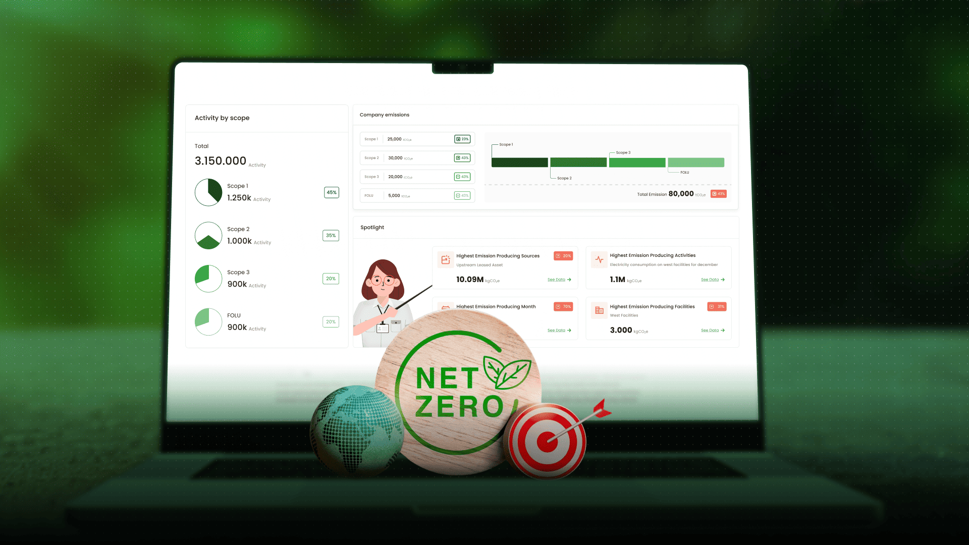
This is where a platform like CarbonAtlas plays an important role in building an integrated dMRV system.
CarbonAtlas is designed to connect three main components in the MRV process.
With this integration, an organization not only has complete data, but also a system capable of showing the relationship between field activities, geographic location, and the resulting carbon report.
This approach helps strengthen the credibility of reports and accelerates the audit process in decarbonization programs or nature-based carbon projects.
The transition toward a low-carbon economy requires a data system that is transparent and trustworthy. A strong MRV is key to ensuring that every emission reduction claim is supported by clear evidence.
Integrating digital technology and spatial systems through the dMRV approach opens up opportunities to improve the accuracy, transparency, and efficiency of carbon reporting.
Through a platform like CarbonAtlas, an organization can connect field data, spatial information, and the verification process within a single integrated system.
If your organization is building a carbon reporting system or a climate project, the spatial dMRV approach can be an important step to ensure that the data you produce is not only complete, but also credible and audit-ready.


Jejakin’s green programs combine high-tech monitoring, biodiversity restoration, and community-led initiatives to deliver powerful, sustainable change across ecosystems.