Tech and Innovation

In the past, monitoring forest conditions could only be done through field surveys that required a lot of time and effort. Today, satellites allow us to observe forest changes, air quality, and even the direct impacts of climate change from a laptop screen.
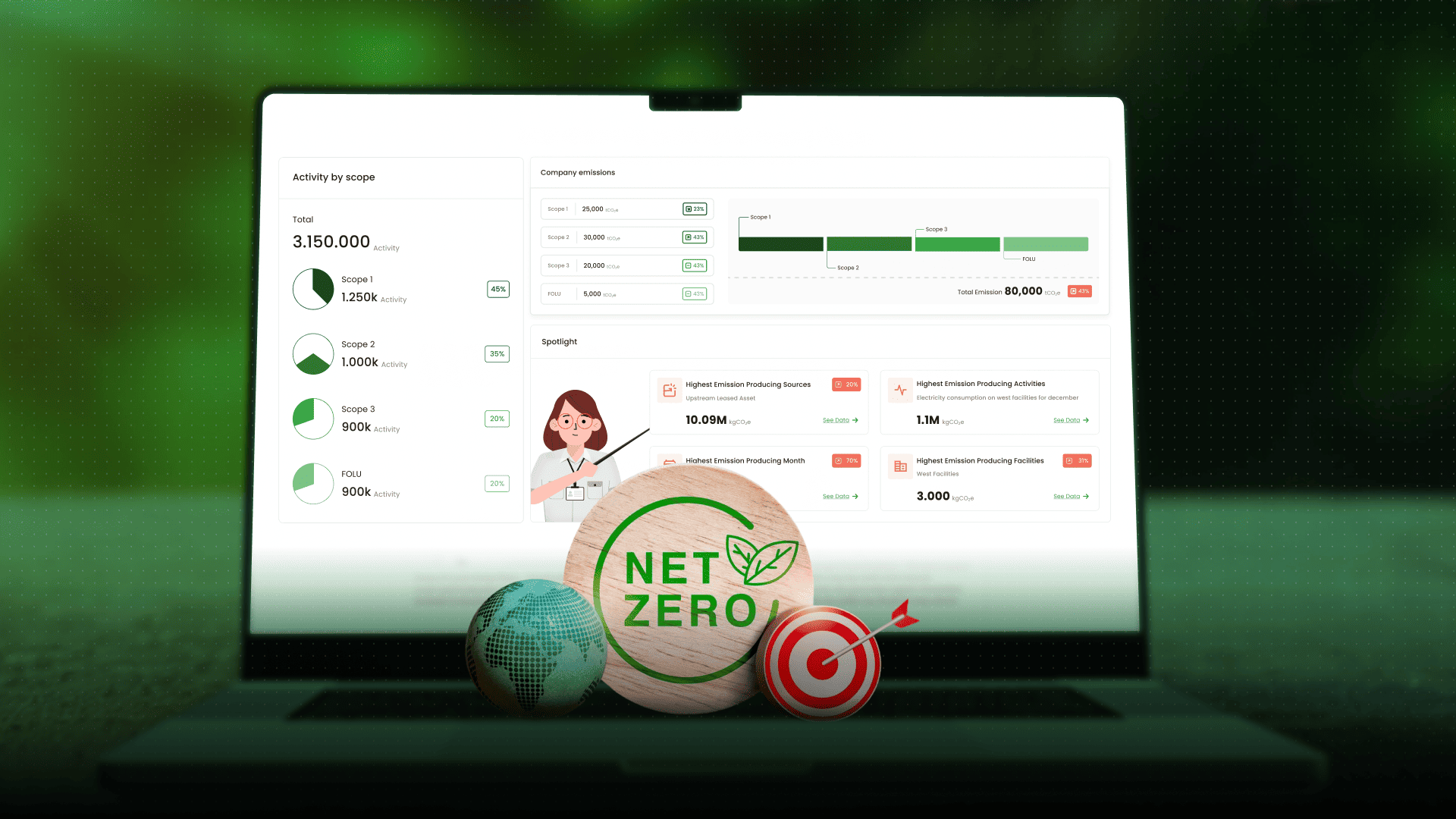
This technology provides fast, comprehensive, and accurate data. For Jejakin, satellites are not just a monitoring tool but also a crucial foundation for conservation efforts. Through CarbonAtlas, satellite data is combined with IoT and AI to deliver transparent information that can be easily used by governments, businesses, and the public to make more sustainable decisions.
One of the main benefits of satellites is their ability to detect changes in forest cover. With satellite imagery, researchers can see how much forest has been lost due to land conversion for plantations, mining, or infrastructure development.
In Indonesia, this data is often used as a reference to monitor deforestation trends. Satellite analysis can show which primary forests remain intact, which have turned into secondary forests, and which have been converted into non-forest land.
At Jejakin, we use this capability in CarbonAtlas to give governments, businesses, and communities a clearer picture. The goal is simple: to provide data that can be directly applied to designing policies and taking concrete action to protect Indonesia’s forests.
Satellites do not only detect land cover but also help measure vegetation health. One of the most popular methods is NDVI (Normalized Difference Vegetation Index). This index is used to calculate the level of greenness of vegetation based on the light reflected from plant leaves.
A high NDVI value indicates healthy vegetation with optimal photosynthesis. On the other hand, a low NDVI value may indicate stress, for example due to drought or forest fires. NDVI data is very important for monitoring tropical forests such as those in Indonesia, where biodiversity is highly vulnerable to climate change and human activities.
With this indicator, we can predict fire risks, assess the impacts of climate change on ecosystems, and design more accurate protection strategies.
Satellites can also detect hotspots that signal the early stages of forest and land fires. This data is often used by agencies such as BMKG to issue early warnings to the public.
MODIS and VIIRS satellites can even detect fire locations in real-time. This information is not only useful for firefighters but also for monitoring air quality. Transboundary haze, such as that which occurred in Southeast Asia due to forest fires in Indonesia, can be tracked in its spread using satellite data.
For Jejakin, this technology supports transparency in environmental monitoring. Through CarbonAtlas, satellite data is combined with IoT sensors to provide a more accurate picture of forest and air conditions, enabling governments and businesses to take quicker and more precise actions.
Climate change presents major challenges in forest management. Satellites play a vital role in understanding weather patterns, global temperature increases, and forest loss due to ecosystem shifts. This data can also indicate how much carbon is stored in forests, making it useful for designing climate mitigation policies.
In conservation, satellites help protect wildlife habitats. For example, satellite data can map critical areas for orangutans in Kalimantan or Sumatran tigers whose habitats are shrinking due to forest fragmentation. With this information, wildlife corridors can be designed so that they still have safe spaces to move.
Despite its significant benefits, the use of satellite data also faces challenges. First, raw satellite data requires further analysis to be properly interpreted. Not all parties have the technical capacity and resources to conduct such analyses.
Second, there are limitations in image resolution. Although many high-resolution satellites exist today, access costs can be quite expensive. In addition, cloud cover in tropical regions often complicates observations.
Third, satellite data needs to be validated with ground truth data to ensure its accuracy. Therefore, integration between technology and human participation remains important.
In the future, satellite technology will become even more advanced. Higher image resolution, integration with Artificial Intelligence (AI), and lower costs will make satellite data more accessible and useful to various stakeholders.
Another innovation is combining satellites with IoT sensors on the ground. Satellites provide a broad overview from above, while sensors provide detailed conditions at specific points. Together, they create a much more precise and real-time environmental monitoring system.
In the future, collaboration between satellite technology, AI, and ground data will be key to protecting forests, biodiversity, and tackling the challenges of climate change.
Satellites have opened our eyes to the importance of maintaining ecological balance. From monitoring deforestation to analyzing air quality, this technology gives us the opportunity to understand the Earth in ways never before possible. However, data is only the beginning. The real challenge is how we translate this information into policies, actions, and real solutions.
This is where platforms like CarbonAtlas by Jejakin play a role. As a climate tech company in Indonesia, Jejakin also utilizes satellite data, IoT, and science-based analytics to help organizations, businesses, and governments make better decisions regarding conservation and carbon management. Visit CarbonAtlas to see more details.


Jejakin’s green programs combine high-tech monitoring, biodiversity restoration, and community-led initiatives to deliver powerful, sustainable change across ecosystems.